How a Caldera Is Made
The island that isn’t an island anymore
The first time I stood on the rim in Imerovigli and looked down at the water, it took me a moment to understand what I was actually seeing. It isn’t a bay. It isn’t a lagoon. It’s a wound — the missing centre of what used to be a single, round volcanic island, now filled with 300 to 400 metres of sea. Everything you notice first in Santorini, the cliffside villages, the black-sand beaches on the far side, the two dark islets sitting in the middle of the water, is downstream of one event. I wanted to understand that event before I tried to describe the view.
What a caldera actually is
People use “crater” and “caldera” interchangeably, and they aren’t the same thing. A crater is punched outward by an explosion, like a bowl blasted into the ground. A caldera collapses inward. Beneath a volcano sits a magma chamber, a reservoir of molten rock. When an eruption empties that chamber fast enough, the rock roof above it no longer has anything to rest on, and it caves in under its own weight.
What you’re left with isn’t a hole from an explosion — it’s a basin from a collapse. Santorini’s caldera is roughly 12 km long and 7 km wide, and the inner cliff you see from Fira or Oia rises 250 to 300 m almost straight out of the water. That wall is the exposed cross-section of the island that used to be there.
The eruption that did it
The event responsible is what geologists call the Late Bronze Age eruption, or the Minoan eruption, and I’ll say upfront that I can’t give you a clean date, because nobody can. Radiocarbon evidence points to around 1600 BC. Archaeological chronology, built on comparisons with dated objects in Egypt and the wider Aegean, points closer to 1500 BC. The two methods haven’t converged, and every guide, museum panel, or article that hands you a single confident year is smoothing over a real, unresolved argument. “Around 1600 BC” is the honest version.
Whatever the exact year, it was one of the largest eruptions of the last several thousand years, ejecting an enormous volume of pumice and ash — some of it found as far away as Crete and in ice cores from Greenland. At Akrotiri, the Minoan town buried by that ash, archaeologists have found no human remains, which suggests the population had enough warning, likely from earlier tremors and smaller explosions, to leave before the worst of it. The Akrotiri excavations are the closest you can get to standing inside that moment, and the frescoes recovered there are now held at the Museum of Prehistoric Thera in Fira.
It’s tempting to reach for the Atlantis story here, and plenty of writers do. I’d rather be precise: the link between Santorini and Plato’s Atlantis is a modern hypothesis, popularised in the twentieth century, not an established fact. It’s worth reading about if you’re curious — I’ve laid out the argument and its problems in the Atlantis myth guide — but it belongs in the same category as an interesting theory, not history.
What was left behind
Before the eruption, Thira was closer to a single, more or less continuous island with a volcanic peak near its centre. Afterward, the centre was gone, replaced by open sea, and the surviving rim broke into the pieces you can name on a map today: the main crescent of Thira itself, Thirassia facing it across the water, and the small uninhabited rock of Aspronisi to the southwest. The highest surviving point on the main island, the Profitis Ilias summit at 567 m, sits well inland from the caldera rim — a reminder that the collapse didn’t flatten everything, it hollowed out one section of a much larger volcanic structure.
The two black islets sitting inside the caldera today, Nea Kameni and Palea Kameni, weren’t there when the eruption happened. They’re newer growth. Since the Bronze Age collapse, the volcano hasn’t gone quiet — it has kept rebuilding inside its own basin through a long, uneven sequence of smaller eruptions, the most recent in 1950, with earlier activity in the 1920s, 1930s and back to 1707.
Nea Kameni is the active cone people walk up to today; Palea Kameni is older and known now for the warm, iron-tinted water near its shore rather than for anything erupting. I’ve gone into both in separate detail — what Nea Kameni actually is up close, and what the hot springs at Palea Kameni are really like — because visiting them is a different subject from understanding how they got there.
No, you will not see lava
I want to be direct about this because it’s the single most common expectation I run into: there is no lava to see in Santorini today, and there hasn’t been since 1950. What tour boats show you on Nea Kameni is solidified volcanic rock, sulphurous vents, and warm ground you can feel through your shoes — not flowing lava. If a photo or a headline implies otherwise, it’s either old, staged, or wrong.
That said, the volcano is not a museum piece. In early 2025, a long earthquake swarm developed between Santorini and Amorgos — thousands of small quakes over about six weeks, some strong enough to prompt a local state of emergency and a wave of departures from the island. It never produced an eruption, and researchers who studied it afterward have generally attributed it to magma moving through a deep rock fracture rather than rising toward the surface.
I mention it here because it belongs in any honest account of the caldera’s geology, not as a scare story, and not as reassurance that nothing could ever happen — just as part of what this landscape still is: dormant, watched, and occasionally restless. If safety is what brought you to this topic, I’ve written about it directly in the 2025 earthquake guide.
Why I’d rather see it from the water
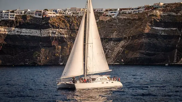
Reading about a collapsed magma chamber is one thing; understanding its scale is another, and for me that only clicked once I was actually on the water, looking up at the cliff instead of down from it. From the rim, the caldera reads as a view. From a boat below it, it reads as a wall — you can trace the layers of ash and lava in the rock face and get a sense, finally, of just how much material is missing from the middle of this island.
an evening cruise into the caldera puts you right against that cliff face as the light changes, which is when the layering in the rock shows up best. If you’d rather see the seabed as well as the walls, a glass-bottom boat tour of the caldera lets you look straight down into water that’s often 300 m deep just metres from where you’re floating.
For a slower, half-day version with food included, a morning sailing cruise with a meal on board covers more of the rim at an easier pace, and if you want the volcanic islets and the sunset in one outing, a caldera cruise with the hot springs and an Oia sunset option ties the geology and the view together in a single afternoon.
If you want the full mechanics of how the eruption is currently understood, laid out step by step rather than woven through a personal account, I’ve put that together separately in how the Santorini caldera was formed, and if you’re comparing which boat trip actually suits what you want to see, the caldera cruise guide and how the volcano tours compare are the two pages I’d read next.
Questions people ask me about the caldera
When exactly did the eruption happen?
Nobody can give you a single year. Radiocarbon dating points to around 1600 BC, while Egyptian and Aegean archaeological chronologies suggest closer to 1500 BC. The gap between the two methods has never fully closed, so any date you read should be treated as an estimate, not a certainty.
Can I still see lava in Santorini?
No. The last eruption was in 1950, and it produced no lava flows you can visit today. What you see on Nea Kameni is cooled, hardened rock and steaming ground, not active lava.
Is the caldera a crater?
Not in the simple sense. A crater is a hole punched by an explosion; a caldera is a much larger basin formed when the ground above an emptied magma chamber caves in. Santorini’s caldera swallowed most of what used to be a single round island.
What are Nea Kameni and Palea Kameni?
They are volcanic cones that have grown inside the caldera since the Bronze Age collapse, built up by a long series of smaller eruptions, the most recent in 1950. They are the only part of the archipelago still considered active.
How deep is the caldera?
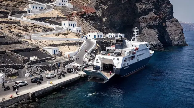
The water inside it reaches depths of around 300 to 400 m in places, which is part of why ferries and cruise ships can sail so close to the cliffs without running aground.
Did the eruption really destroy Minoan civilisation?
It’s a popular theory but not a settled one. The eruption clearly devastated Santorini itself and likely triggered tsunamis felt across the Aegean, but Minoan Crete’s decline played out over a longer period and probably had several causes, not one single event.
Is Santorini’s volcano still dangerous today?
It’s monitored closely, and the 2025 earthquake swarm near Santorini and Amorgos, which lasted about six weeks and produced thousands of small quakes, raised the same question. It never led to an eruption, and scientists have linked it to magma moving through a deep rock fracture rather than a build-up toward one. The volcano is watched, not on any known countdown.
tours.Explainer
Verified deep-linked GetYourGuide tours. Book through these links and we earn a small commission at no cost to you.
GetYourGuide does not provide a product photo for this activity — the image shows the meeting point, photographed by us.