How the Santorini Caldera Was Formed
How was the Santorini caldera formed?
The caldera was carved by a massive Bronze Age eruption of the volcano then called Strongyle, dated to around 1600 BC, which emptied the magma chamber and caused the island's center to collapse into the sea. The dark islets of Nea Kameni and Palea Kameni later grew back up from the seabed inside that flooded crater over the following centuries.
The View That Needs an Explanation
Stand on the edge of Fira or Oia at almost any hour and the same question tends to surface: why does the land just stop like this? Villages perch on a sheer wall that drops 250 to 300 meters into a bay so deep in places that cruise ships anchor without touching bottom. Across the water sit two dark, treeless islets that look like they were dropped there yesterday. None of this is ordinary coastal erosion. It is the scar of one of the largest volcanic events of the last several thousand years, followed by a much slower second act that is technically still running.
This page is about that sequence: what the island looked like before, what happened during the eruption that broke it apart, and how the caldera has continued to change since, right up to the earthquake swarm of 2025. For what you can actually do on or near the volcano today, see Nea Kameni volcano guide, Palea Kameni hot springs guide, and Santorini volcano tours compared. For the buried Bronze Age town at the foot of it all, see Akrotiri excavations guide.
Before the Bang: An Island Called Strongyle
Long before it looked anything like today’s crescent, the volcano here built up a roughly circular island that ancient writers called Strongyle, “the round one.” It was not the first volcanic edifice on this spot — geologists have identified several earlier eruptive cycles stretching back hundreds of thousands of years, each one building a cone that later collapsed or was partly destroyed by an eruption, only for the volcano to rebuild on top of the wreckage. Santorini’s geological history is really a stack of these cycles, and the Bronze Age event was simply the most recent major one, not the only one.
By the second millennium BC, Strongyle supported a thriving community. The best evidence for that community is at Akrotiri, a Minoan-era town on the island’s southern coast that traded across the Aegean and as far as Crete and Egypt. Its buildings, frescoes, and pottery show a settlement that was comfortable, connected, and apparently unaware of — or unwilling to read — the signs building beneath it.
The Minoan Eruption, Somewhere Around 1600 BC
The eruption that ended Strongyle as a single island is usually called the Minoan eruption, named for the Bronze Age Aegean culture living there at the time, not because Minoan Crete caused or controlled it. It ranks among the largest eruptions of the last 10,000 years, comparable in scale to Indonesia’s 1815 Tambora eruption, and it unfolded over roughly four phases: an opening explosive blast, a period of pumice fall that buried the landscape in meters of pale volcanic debris, pyroclastic flows racing across the island, and finally the catastrophic emptying of the magma chamber that triggered the collapse discussed below.
Dating this event precisely has turned into one of the longer-running arguments in Mediterranean archaeology. Radiocarbon dating of seeds, wood, and other organic material caught in the ash consistently points to a date around 1600 BC. Traditional archaeological chronology, built by cross-referencing Aegean pottery styles found alongside Egyptian objects with the more securely dated Egyptian historical record, tends to favor a somewhat later date, closer to 1500 BC. Neither side has fully persuaded the other, and periodic new studies push the conversation back and forth by a few decades without settling it. The honest way to describe the date, and the one used throughout this site, is “around 1600 BC” — a working estimate, not a fixed year.
What is not in dispute is the human side of the story at Akrotiri. Excavators have found no human skeletons from the eruption itself, and no valuables left behind in a hurry — no jewelry, no coin hoards. The pattern suggests the population had enough warning, likely from preceding earthquakes and smaller eruptive activity, to pack essentials and leave before the worst of it. Whether they escaped by boat across open water or simply weren’t there is something we still don’t know for certain.
What the Eruption Left Behind: A Collapsed Center
The detail that actually shapes the landscape you see today isn’t the explosion itself but what happened afterward. As the eruption emptied an enormous volume of magma from the chamber beneath the island, the rock roof over that now-hollow space lost its support. Large sections of Strongyle’s center collapsed downward and inward, dropping below sea level.
The Aegean rushed in to fill the resulting basin, and what had been one round island became several: the long crescent of Thira itself, Thirassia facing it across the water, and the small uninhabited rock of Aspronisi to the southwest. The flooded basin between them — the caldera — is roughly 12 km long and 7 km wide, and in places over 300 meters deep.
This is also why the caldera-facing villages sit where they do and look the way they do. Fira, Firostefani, Imerovigli, and Oia are all built along the rim of the collapse, on what is essentially the exposed cross-section of the old volcanic edifice — which is why the cliffs beneath them show visible bands of different-colored rock, each layer a separate chapter of the island’s eruptive past.
None of these villages has a beach at its foot; the drop is simply too steep and too deep. Santorini’s beaches are on the outer, gentler slopes at Kamari, Perissa, and Perivolos, well away from the caldera wall.
A Volcano Reborn: Nea Kameni and Palea Kameni
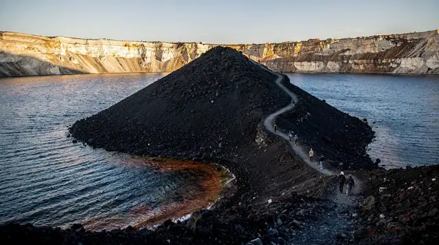
A collapsed caldera does not mean a dead volcano, and Santorini’s has spent the last two thousand or so years proving it. The magmatic system beneath the flooded crater stayed active, and new eruptions — smaller than the Bronze Age event, but real eruptions all the same — have gradually built two islets up from the caldera floor, roughly at its center.
Palea Kameni (“old burnt one”) came first, forming through eruptions recorded in antiquity and again in the medieval period. Nea Kameni (“new burnt one”) is the younger and larger of the two, built up in a series of documented eruptions from the 16th century onward — activity recorded in 1570-73, 1707-11, 1866-70, 1925-28, 1939-41, and most recently 1950, which remains the last eruption anywhere in the caldera. Each event added fresh lava and ash to the islet, and the cone visitors climb today on Nea Kameni is that cumulative record, not a single event frozen in place.
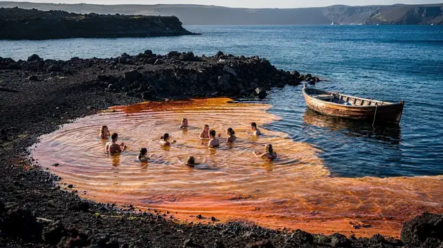
The warm, mineral-tinted waters people swim to near Palea Kameni are a direct byproduct of this ongoing activity: submarine fumaroles vent gases and heat that color the sea rust-orange with dissolved iron near the shore. It is real geothermal activity, not a heated pool — worth knowing before jumping in expecting bathwater, and worth knowing that the color stains pale swimwear. For what a visit there actually involves, see Palea Kameni hot springs guide and Nea Kameni volcano guide.
Between eruptions, the volcano goes quiet for decades at a time, occasionally waking with earthquake swarms, gas releases, or slow ground uplift that stop short of an eruption. That pattern is exactly what happened most recently in 2025.
Is Santorini Still Restless? The 2025 Earthquake Swarm
In late January 2025, an intense earthquake swarm began in the sea between Santorini and Amorgos. Over roughly forty days, seismographs recorded more than 28,000 tremors, some reaching magnitude 5.2, prompting local schools to close, a temporary state of emergency, and the departure of several thousand residents and workers as a precaution. It was, by any measure, an unusual few weeks.
It was also not an eruption, and studies published since have generally attributed the swarm to a dike — a sheet of magma intruding upward through the crust from a deep reservoir — rather than to magma nearing the surface in a way that threatened an imminent eruption. The swarm ended, activity returned to background levels, and the island’s volcano-monitoring network continues to track the area as it always has.
It’s a genuinely useful data point for understanding how alive this landscape still is beneath the surface, but not a reason to expect an eruption tomorrow, next year, or on any predictable timeline. For a fuller account of what happened and what changed, see Santorini safety and the 2025 earthquakes and What actually happened in Santorini in 2025.
Reading the Layers: Rock You Can See Today
Most of what’s described above isn’t abstract — it’s visible in the rock itself, if you know roughly what you’re looking at. The pale cliffs at Vlychada, carved by wind and rain into fluted, almost lunar shapes, are compacted volcanic ash from past eruptions rather than sedimentary rock.
The exposed strata around Red Beach get their color from oxidized iron in the volcanic material, layered in bands that record separate eruptive episodes stacked over time. And the caldera wall itself, followed on foot along the Fira-to-Oia caldera path, is effectively a cross-section through the volcano’s history, with lighter pumice bands from explosive phases sitting alongside darker lava layers from quieter periods.
None of this requires geological training to appreciate. It helps explain why the island’s wine terraces at Pyrgos and around the wineries grow in mineral-rich volcanic soil rather than ordinary earth, why there is no natural fresh water anywhere on the island, and why the highest point, Profitis Ilias at 567 meters, is a remnant of older, pre-eruption volcanic building rather than part of the caldera rim itself.
Seeing the Caldera for Yourself
Reading about a collapsed volcano is one thing; sitting inside it is another. Most visitors get their clearest sense of the caldera’s scale from the water, looking back up at the walls rather than down from them. A caldera cruise that stops at the hot springs before ending under an Oia sunset covers most of the story in one afternoon: the volcanic islets at the center, the geothermal water near Palea Kameni, and the layered cliffs lit up as the light changes. A shorter three-hour catamaran cruise around the caldera works well if a full day on the water isn’t the plan.
For a longer day that circles closer to the volcanic islets themselves, a catamaran cruise around the volcanic island gives more time near Nea Kameni’s dark shoreline before the boat turns toward the swimming stops.
And for anyone who prefers to see the whole arc — cliffs, islets, and sunset — with dinner included, the sunset catamaran cruise with swim stops and a barbecue dinner turns the geology lesson into a full evening out. Details on what each type of cruise actually includes, and how they compare, are in caldera cruise guide for Santorini.
Frequently Asked Questions About the Santorini Caldera’s Formation
When did the eruption that created the caldera happen?
Most likely around 1600 BC, in the Late Bronze Age. Radiocarbon dating points to roughly 1600 BC, while some archaeologists who cross-reference pottery styles with Egyptian records argue for a date closer to 1500 BC. The gap has never been fully closed, so no single year should be treated as certain.
What was Santorini called before the eruption?
Ancient sources refer to it as Strongyle, meaning “the round one,” describing a roughly circular volcanic island rather than the crescent that exists today. The eruption is what broke that shape apart.
Is the caldera one giant crater?
Not exactly. It is a collapse structure, formed when the roof over an emptied magma chamber gave way and the ground sank below sea level, letting the sea flood in. It is larger and more irregular than a typical volcanic crater, roughly 12 km by 7 km.
Did the Minoan eruption destroy an Atlantis-like civilization?
It destroyed a Bronze Age Aegean settlement at Akrotiri, and the eruption’s scale has long fed the popular idea that it inspired Plato’s Atlantis story. That link is a hypothesis, not an established fact, and archaeologists remain divided on it. More on this in Santorini and the Atlantis myth.
How did Nea Kameni and Palea Kameni appear?
They are post-eruption volcanic islets that grew from repeated eruptions on the caldera floor over roughly two thousand years, long after the Bronze Age collapse. Palea Kameni emerged first, in antiquity, and Nea Kameni built up in stages through eruptions recorded between the 1570s and 1950.
Is the Santorini volcano still active?
Yes. Its last eruption was in 1950, and it is monitored continuously. A seismic swarm in early 2025 raised concern but did not lead to an eruption, and activity has since settled.
Where can I actually see the volcanic layers up close?
The ash cliffs at Vlychada and the exposed strata behind Red Beach show the layered pumice and ash from past eruptions most clearly, and the caldera walls seen from the Fira-to-Oia path reveal the same story from a distance.
Volcano and Hot Springs on GetYourGuide
Verified deep-linked GetYourGuide tours. Book through these links and we earn a small commission at no cost to you.
GetYourGuide does not provide a product photo for this activity — the image shows the meeting point, photographed by us.