Fira: Santorini's Cliff-Top Capital
Is Fira the capital of Santorini, and does it have a beach?
Yes, Fira is Santorini's capital and the seat of the Dimos of Thira, the island's municipal government. It sits roughly 250 metres above the sea on the rim of the caldera, so it has no beach and no direct water access — swimming beaches are on the island's east and south coasts.
The seat of the island’s government
Every Cyclades island has an administrative centre, and on Santorini that role belongs to Fira. Officially it’s the seat of the Dimos of Thira — the municipal authority that governs the entire island, from Oia in the north to Akrotiri in the south, along with Thirassia across the water. The town hall, the main police station, the principal health centre, and the island’s central bus terminal are all here. If you need an official document, a pharmacy open late, or the bus to almost anywhere on Santorini, Fira is where you end up.
This administrative weight is easy to miss on a short visit, because Fira also happens to sit on the most photographed stretch of caldera rim outside Oia. Tourism and governance share the same clifftop, and the town’s layout reflects both: souvenir shops and jewellery stores along the caldera-edge lanes, and a quieter grid of municipal buildings, schools, and apartment blocks a few streets back, where residents actually live.
Fira isn’t a single historic quarter frozen in time — it’s a working town that happens to have one of the most dramatic settings in Greece. Understanding that split matters more than any list of things to photograph, because it explains what Fira offers and what it doesn’t.
A town on top of a cliff, not beside the sea
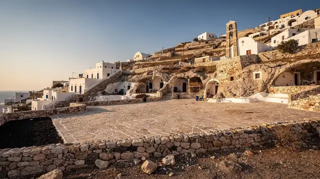
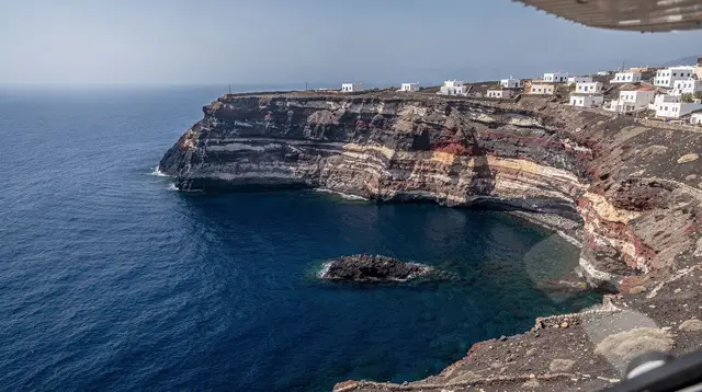
The single fact that shapes everything about visiting Fira is elevation. The town sits on the rim of the Santorini caldera, roughly 250 metres above the water, on a stretch of cliff formed by the collapse that followed the Bronze Age eruption. There is no beach in Fira, no waterfront promenade at sea level, and no way to walk from the town centre straight into the water.
The only connection between Fira and the sea below is the old port, a small harbour known locally as Skala, used by cruise-ship tenders and caldera excursion boats rather than swimmers. Getting down to it means the cable car, the 588 stepped switchbacks cut into the cliff face, or a mule. None of these routes leads to sand — they lead to a working jetty where boats dock.
If a swimming beach is part of your plan, it belongs elsewhere on the island. Santorini’s beaches — black sand at Kamari and Perissa, long stretches at Perivolos, the ash cliffs above Vlychada — sit on the flatter east and south coasts, a drive or bus ride from Fira, not a walk down from it. This is worth stating plainly because Fira’s postcard views over water lead some visitors to assume a beach is close by. It isn’t.
What the clifftop position does give Fira is the view itself: an open sweep across the caldera to Nea Kameni, the volcanic islet at the centre of the bay, and further out to Thirassia. The town’s edge is lined with terraces and churches built specifically to look at that view, which is a different kind of asset than a beach, and arguably a rarer one.
The Museum of Prehistoric Thera
Fira’s most substantial cultural institution is the Museum of Prehistoric Thera, and it’s the clearest reason to treat the town as more than a viewpoint with restaurants attached. The museum holds finds from Akrotiri, the Minoan-era town buried by volcanic ash in the eruption dated to around 1600 BCE — wall paintings, pottery, furniture impressions, and everyday objects that survived because the site was sealed rather than destroyed.
Akrotiri itself, on the island’s south coast, is where the excavation happens and where the frescoes were found in place. But it’s Fira’s museum that keeps a significant share of that material on permanent display, in a town setting rather than at the dig. For visitors who want to understand what Bronze Age life on the island looked like before deciding whether to make the trip south to the excavation itself, the museum in Fira is the natural starting point.
The exhibits also help make sense of a detail worth knowing before you go further into the island’s history: no human remains have been found at Akrotiri, which points to the population having had warning and time to leave before the eruption. The precise date of that eruption is still debated among specialists — radiocarbon dating and archaeological chronology don’t fully agree — so it’s usually given as “around 1600 BCE” rather than a fixed year. The museum doesn’t resolve that debate, but its collection is the physical evidence at the centre of it.
A mixed religious and architectural history
Fira’s skyline carries two church traditions rather than one. The Orthodox Metropolitan Cathedral anchors the town from below, rebuilt after the earthquake of 1956 that damaged much of Santorini, while a Catholic quarter sits above it — a legacy of the centuries when Venice controlled the Cyclades and “Santorini” (from Saint Irene) became the name that stuck alongside the older Thira.
That layered history is part of why the island carries two names side by side to this day: Thira as the official Greek designation and the name of the municipality, Santorini as the name most visitors know it by. Fira’s own architecture — a denser, more built-up centre than the smaller caldera villages — reflects centuries as the practical hub of island life, not just as a stage for sunset photographs.
Fira in relation to the rest of the caldera rim
Fira sits at the midpoint of the string of clifftop settlements that make up the caldera’s western edge. To the north, the path along the rim continues through Firostefani and Imerovigli — quieter, more residential extensions of the same cliff — on the way toward Oia at the island’s northern tip. That whole stretch can be walked as the Fira-to-Oia caldera path, a route that starts paved and easy near Fira and turns to open dirt track further along.
Inland, a short drive from Fira brings you to villages with a different character entirely: the hillside town of Pyrgos, the only spot on the island with a clear view of Santorini in every direction, and the residential village of Messaria, with its neoclassical mansions built by 19th-century merchant families. Nearer to Fira itself, Karterados offers a quieter, more residential alternative for travellers who want proximity to the capital’s services without staying in its busiest lanes.
This guide doesn’t attempt a street-by-street walking route through Fira’s old town — that’s covered separately in the Fira old town walk — and it doesn’t set out to rank Fira against Oia, Imerovigli, or Pyrgos for where to stay, which is the job of the Santorini villages guide. What matters here is Fira’s role: administrative capital, transport hub, and the town where the island’s prehistoric collection lives, distinct from its reputation as a sunset backdrop.
Fira as a transport and logistics hub
Because it’s the municipal seat, Fira is also where Santorini’s transport network converges. The central KTEL bus station sits just off the caldera-edge lanes and is the departure point for routes to nearly every part of the island, including the beaches, Akrotiri, and Oia. Athinios port, the island’s only ferry port, is a short taxi or bus ride away, at the base of a switchback road below the caldera rim. The airport is similarly close.
That centrality is a practical reason travellers choose to base themselves in or near Fira even when the town’s own views compete with Oia’s more famous ones: onward journeys, whether to the ferry, the airport, or a day trip to another village, tend to start from here.
Visiting Fira on a cruise-ship day
Fira absorbs a large share of Santorini’s cruise traffic, since tenders dock directly below the town at the old port. On days when ships are anchored in the caldera, the cable car and the 588 steps both see steady queues from mid-morning onward, and the caldera-edge lanes fill accordingly. Santorini currently caps cruise arrivals at 8,000 passengers a day, and a per-passenger cruise levy — charged by the cruise line, not collected at a gate — funds some of the island’s infrastructure. None of that changes the geography: whichever way you come up from the port, you arrive in the same town, at the same busy hours.
Travellers doing a single day in Santorini from a ship often see the old port and the cable car as their first and last impressions of the island. Arriving early or staying until the later tender departures — rather than moving through Fira in the crowded midday window — tends to make for a calmer visit.
Where a guided tour fits
Because Fira itself is compact and mostly self-explanatory once you know its layout, most travellers use it as a starting or meeting point for tours that head elsewhere on the island rather than as a destination requiring a guide of its own. A sunset tour that combines Oia, Pyrgos, and a winery stop typically departs from central pick-up points including Fira, making it a convenient way to see the inland villages and the caldera’s western light in one outing without arranging your own transport.
For a slower, more structured look at the island’s history and geology beyond Fira’s own museum, a guided walk from Profitis Ilias mountain down to Ancient Thira covers ground the town itself doesn’t — the island’s highest point and its Dorian-era hilltop city, both a short drive from the capital. And because itineraries and interests vary widely, a customisable private tour with local guide pick-up lets you build a day around Fira’s transport links without committing to a fixed group route.
Deciding whether to base yourself in Fira
Fira’s case for a home base rests on convenience rather than scenery alone: central buses, proximity to the port and airport, a wide range of restaurants and shops, and the island’s clearest cultural institution in the Museum of Prehistoric Thera. What it doesn’t offer is a private caldera-view balcony experience to the degree that smaller, quieter villages like Imerovigli or Oia are known for, nor any beach access of its own.
For a broader comparison of where to stay across the island — including the trade-offs between Fira’s convenience and the caldera villages’ views — the where to stay in Santorini guide and the Santorini villages guide go into more detail than makes sense here. It’s also worth a brief look at the 2025 earthquake swarm if safety and seasonality are part of your planning — the sequence affected the whole island administratively, including Fira as its capital, and is now over.
If you’re planning a single day that includes Fira alongside the island’s other highlights, the one day in Santorini itinerary sets out how the capital fits alongside Oia’s sunset and the caldera villages further north.
Questions about visiting Fira, Santorini’s capital
Is Fira the capital of Santorini?
Yes. Fira is the administrative seat of the Dimos of Thira, the municipality that governs the whole island, including Oia, Pyrgos, and the southern villages. It holds the town hall, the main hospital, the police headquarters, and the island’s principal bus terminal.
Does Fira have a beach?
No. Fira sits on top of the caldera cliff, around 250 metres above the water, with no direct beach access. The nearest shoreline below town is the small old port of Skala, used by cruise tenders and excursion boats, not for swimming. Santorini’s swimming beaches — Kamari, Perissa, Perivolos, Vlychada — are on the flatter east and south coasts.
What is there to see in Fira besides shopping and restaurants?
The Museum of Prehistoric Thera holds frescoes, pottery, and everyday objects excavated at Akrotiri, giving Fira the island’s clearest record of life before the Bronze Age eruption. The Orthodox Metropolitan Cathedral and the Catholic quarter above it reflect the town’s mixed Venetian and Greek Orthodox history, and the caldera-edge promenade gives uninterrupted views toward Nea Kameni and Thirassia.
How do I get down to the old port from Fira?
Three ways: the cable car, which takes about three minutes and covers roughly 220 metres of descent; the 588 steps on foot; or by donkey. There is no requirement to use the donkeys, and most visitors find the cable car or the steps more straightforward.
Is Fira a good base for a Santorini trip?
It works well if you want central logistics — buses to most of the island leave from Fira, and Athinios port and the airport are both a short drive away. It suits travellers who prioritise convenience and town life over a private caldera-view balcony, which is more the reputation of Oia and Imerovigli.
Is Fira the same as Thira?
Not quite. Thira is the island’s official Greek name and also the name of the municipality (Dimos Thira), while Fira is specifically the capital town. You’ll see both names used loosely for the town itself, but Thira properly refers to the whole island or the administrative district.
Is Fira busy with cruise passengers?
Yes, on days when ships are anchored offshore. Passengers arrive by tender at the old port and ride the cable car or walk up, filling the caldera-edge streets from mid-morning to late afternoon. Early morning and evening are calmer.
Villages and Culture on GetYourGuide
Verified deep-linked GetYourGuide tours. Book through these links and we earn a small commission at no cost to you.
GetYourGuide does not provide a product photo for this activity — the image shows the meeting point, photographed by us.